| font | ||
| .gitignore | ||
| Aircraft.cpp | ||
| Aircraft.h | ||
| AircraftLabel.cpp | ||
| AircraftLabel.h | ||
| AircraftList.cpp | ||
| AircraftList.h | ||
| anet.c | ||
| anet.h | ||
| AppData.cpp | ||
| AppData.h | ||
| dump1090.h | ||
| getmap.sh | ||
| gmon.out | ||
| Input.cpp | ||
| Input.h | ||
| interactive.c | ||
| Label.cpp | ||
| Label.h | ||
| magma.h | ||
| Makefile | ||
| Map.cpp | ||
| Map.h | ||
| mapconverter.py | ||
| mode_ac.c | ||
| mode_s.c | ||
| monokai.c | ||
| monokai.h | ||
| net_io.c | ||
| parula.c | ||
| parula.h | ||
| README.md | ||
| run.sh | ||
| run_viz1090.sh | ||
| Style.h | ||
| Text.cpp | ||
| View.cpp | ||
| View.h | ||
| view1090.h | ||
| viz1090.cpp | ||
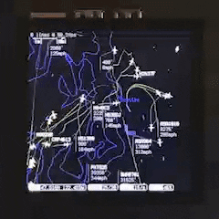
viz1090
This is a work in progress
There are some major fixes and cleanup that need to happen before a release:
- Everything is a grab bag of C and C++, need to more consistently modernize
- A full refactor, especially View.cpp, necessary for many of the new features below.
- A working Android build, as this is the best way to run this on portable hardware.
There are also a lot of missing features:
- Map improvements
- Labels, different colors/line weights for features
- Tile prerenderer for improved performance
- In-application menus for view options and configuration
- Theming/colormaps (important as this is primarily intended to be eye candy!)
- Integration with handheld features like GPS, battery monitors, buttons/dials, etc.
BUILDING
Tested and working on Ubuntu 18.04, Raspbian Stretch / Buster, Windows Subsystem for Linux (with Ubuntu 18.04), and Mac
- Install build essentials
sudo apt-get install build-essential
- Install SDL and RTL-SDR libraries
sudo apt-get install libsdl2-dev libsdl2-ttf-dev libsdl2-gfx-dev librtlsdr-dev libgdal-dev
1b. (Raspberry Pi only) If you are running viz1090 on the Raspbian desktop (or any form of X) you can skip this step, but if you want to be able to start it directly from the command line, do the following to build SDL with KMS driver support. This is taken from this stackoverflow question
git clone https://github.com/libsdl-org/SDL
sudo apt build-dep libsdl2
sudo apt install libdrm-dev libgbm-dev
cd ~/SDL
git checkout SDL2
./configure --enable-video-kmsdrm
make -j4 && sudo make install
Then download and build SDL2_gfx
wget http://www.ferzkopp.net/Software/SDL2_gfx/SDL2_gfx-1.0.4.tar.gz
tar -zxvf SDL2_gfx-1.0.4.tar.gz
cd SDL2_gfx-1.0.4
./configure
make -j4 && sudo make install
And finally SDL2_ttf
git clone https://github.com/libsdl-org/SDL_ttf.git
cd SDL_ttf
git checkout SDL2
./configure --disable-harfbuzz-builtin --disable-freetype-builtin --without-x
make -j4 && sudo make install
- Download and build viz1090
cd ~
git clone https://www.github.com/nmatsuda/viz1090
cd viz1090
make clean; make
- Download and process map data
sudo apt install python3 python3-pip
pip3 install fiona tqdm shapely
./getmap.sh
This will produce files for map and airport geometry, with labels, that viz1090 reads. If any of these files don't exist then visualizer will show planes and trails without any geography.
The default parameters for mapconverter should render reasonably quickly on a Raspberry Pi 4. See the mapconverter section below for other options and more information about map sources.
- (Windows only)
As WSL does not have an X server built in, you will need to install a 3rd party X server, such as https://sourceforge.net/projects/vcxsrv/
- run Xlaunch from the start menu
- Uncheck "Use Native openGL"
- Add parameter
-ac(WSL 2 only) - Open the Ubuntu WSL terminal
- Specify the X display to use (WSL 1)
export DISPLAY=:0 - or for (WSL 2)
export DISPLAY=$(cat /etc/resolv.conf | grep nameserver | awk '{print $2}'):0 - Start viz1090 as described below.
RUNNING
- Start dump1090 (http://www.github.com/MalcolmRobb/dump1090) locally in network mode:
dump1090 --net
- Run viz1090
./viz1090 --fullsceen --lat [your latitude] --lon [your longitude]
viz1090 will open an SDL window set to the resolution of your screen.
RUNTIME OPTIONS
| Argument | Description |
|---|---|
| --server [domain name or ip] | Specify a dump1090 server |
| --port [port number] | Specify dump1090 server port |
| --metric | Display metric units |
| --lat | Specify your latitude in degrees |
| --lon | Specify your longitude in degrees |
| --screensize [width] [height] | Specify a resolution, otherwise use resolution of display |
| --uiscale [scale] | Scale up UI elements by integer amounts for high resolution screen |
| --fullscreen | Render fullscreen rather than in a window |
MAPS
The best map data source I've found so far is https://www.naturalearthdata.com. This has a lot of useful GIS data, but not airport runways, which you can get from the FAA Aeronautical Data Delivery Service (https://adds-faa.opendata.arcgis.com/)
I've been using these files:
The bash script getmap.sh will download (so long as the links don't break) and convert these. Alternatively, you can pass shapefiles and other arguments to mapconverter.py directly
MAPCONVERTER.PY RUNTIME OPTIONS
| Argument | Description |
|---|---|
| --mapfile | shapefile for main map |
| --mapnames | shapefile for map place names |
| --airportfile | shapefile for airport runway outlines |
| --airportnames | shapefile for airport IATA names |
| --minpop | minimum population to show place names for (defaults to 100000) |
| --tolerance" | map simplification tolerance (defaults to 0.001, which works well on a Raspberry Pi 4 - smaller values will produce more detail but slow down the map refresh rate) |
HARDWARE NOTES
This software was originally intended for Raspberry Pi devices, and it is currently optimized for the Raspberry Pi 4 with the following configuration:
- Raspberry Pi 4
- A display:
- Pimoroni HyperPixel 4.0 Display *best overall, but requires some rework to use battery monitoring features of the PiJuice mentioned below
- Waveshare 5.5" AMOLED *this is very good screen but the Google Pixel 2 phone mentioned below has a very similar display for the same price (along with everything else you need in a nice package)
- Waveshare 4.3" HDMI(B)
- Adafruit 2.8" Capacitive Touch
- A battery hat, such as:
- PiJuice Battery Hat *I2C pins must be reworked to connect to the Hyperpixel nonstandard I2C breakout pins, unfortunately
- MakerFocus UPS Hat
- Any USB SDR receiver:
- Noelec Nano V3
- Stratux V2 *very low power but hard to find
If you want to print the case in the GIF shown above, you can download it here.
If running as a front end only, with a separate dump1090 server, the best option is to use an Android phone, such as the Pixel 2, which significantly outperforms a Raspberry Pi 4.
viz1090 has been tested on other boards such as the UP Core and UP Squared, but these boards have poor performance compared to a Raspberry Pi 4, along with worse software and peripheral support, so they are not recommended. viz1090 with a low resolution map will run on these boards or even a Raspberry Pi Zero, so these remain options with some tradeoffs.
Of course, a variety of other devices work well for this purpose - all of the development so far has been done on a touchscreen Dell XPS laptop.
Credits
viz1090 is largely based on dump1090 (Malcom Robb, Salvatore Sanfilippo)